
Attractions

Kenmare Stone Circle, Market Street, Kenmare, County Kerry, Ireland
Kenmare Stone Circle
Kenmare Stone Circle
It is one of the largest Stone Circles in South West Ireland measuring 17.4 x 15.8m (56 x 49ft). Stone Circles were built during the Bronze Age (2,200 – 500 B.C.), believed to be for ritual and ceremonial purposes. They were often orientated on certain solar and lunar events, such as the position of the sun on the horizon on a solstice.
The Kenmare Stone Circle is composed of 15 heavy boulders. At the centre is an impressive Boulder-Dolmen with a giant capstone (2m x 1.8m ). It is unclear as to what the meaning of this monument is, however we do know that Dolmens often marked the burial place of someone important, such as a druid. (hence the local name, “The Druid’s Circle). This style of burial appears to be restricted to the South Munster area, with apparently just one elsewhere in Ireland.
The weight of this capstone must be almost seven tons and at least 30 labourers would have been needed to drag it into position.

Cromwell's Bridge, Bridge Street, Gortamullin, Kenmare, County Kerry, Ireland
Cromwell's Bridge
Single-arch bridge over river, c.1700. Now disused. Sited spanning Finnihy River. NOTE: The bridge, originally named Finnihy Bridge after the river over which its crosses, is possibly the same 'high bridge & one arch' described (1758) by Richard Pococke (1704-65). The bridge is now known as Cromwell's Bridge and a nearby plaque suggests that the name "Cromwell" possibly derived from the Irish "croiméal", meaning moustache, or from an amalgam of the Irish "croim" and "maol", translating as stooped and bald, the latter term applied to bridges without parapets.

Reenagross Woodland Park Kenmare, Killowen, Kenmare, County Kerry, Ireland
Reenagross Woodland Park
The Reengross Woodland is a wood peninsula near the town of Kenmare. The First Marquis of Lansdowne developed the area originally as a private park. It consists of 3KM of walking trails through a diverse range of habitats.
Welcome to Reenagross or Rinn na gCros, Irish for the Headland of the Crosses or the Muddy Point. The park is a wooded peninsula set in Kenmare Bay.
The park has over 3km of walking trails. A diverse range of habitats occur that are home to many plants and animals.
The park is managed by Kenmare Tidy Towns as a place to enjoy nature.

Gleninchaquin Park, Gleninchaquin, Kenmare, County Kerry, Ireland
Gleninchaquin Park
Gleninchaquin Park in County Kerry is a landscape of spectacular natural beauty, ideal for leisurely exploration and peaceful walks. Follow winding streams over log bridges, climb mountain paths with carved steps and wander through rock passages and glens.
Gleninchaquin Park is a family owned park and working farm nestled in a long, narrow valley on the Beara Peninsula. Shaped by glaciation over 70,000 years ago, the landscape has remained largely unchanged. A spectacular 140m waterfall feeds a series of lakes, including Loughs Inchaquin, Uragh, Cloonee, Cummeenaloughaun, Cummeenadillure and Lough Napeasta.
Visitors can enjoy a variety of walking trails through streams and woodlands with scenic viewpoints along the way. With picnic areas, parking, and refreshments available, Gleninchaquin Park is ideal for family outings. Four well marked walking and nature trails cater to all ages, making it an inviting destination for both children and adults.

Torc Waterfall, Torc, Killarney, County Kerry, Ireland
Torc Waterfall
Torc Waterfall Walk
The Torc Waterfall walk in Killarney National Park , County Kerry, offers options ranging from a quick 5-minute stroll to a 5 km or 10 km loop trail . [1, 2, 3]
Length: 4.5 km/ 2.8 mi, allow 2 hours
Difficulty: Moderate
Terrain: Paved lanes and earthen footpaths
Gear: Comfortable walking shoes/boots, raingear, mobile phone, snacks and fluids
Ascent: 150 m
When to go: All year round
Wheelchair Accessible: No
Family Friendly: Yes
Dog Friendly: No
Stopping Points: No set points but some interesting things to see are listed in description below.
Nearest Services: Killarney
Car Parking: There is a parking area located in Muckross House at the start of the trailhead.
Ordnance Survey Map No: 78
Killarney National Park, County Kerry, Ireland
Kilarney National Park
Killarney National Park covers an area of over 26,000 acres incorporating lakes, woodlands, waterfalls, buildings and natural heritage.Killarney National Park, near the town of Killarney, County Kerry, was the first national park in Ireland, created when the Muckross Estate was donated to the Irish Free State in 1932

Kenmare Ice Cream, Henry Street, Kenmare, County Kerry, Ireland
Kenmare Lace, Kenmare Lace and Design Centre, The Square, Kenmare, County Kerry, Ireland
Kenmare Lace
Kenmare Lace is a needlepoint Lace brought to Kenmare by the Poor Clare Nuns in 1861. In order to create employment, the local girls were taught to make this very fine lace. A flourishing lacemaking industry with an emphasis on design grew up around the beautiful lace. We are very proud to follow that tradition at The Kenmare Lace and Design Centre where you can find pieces of locally made Kenmare Lace and other Irish laces, books on lacemaking lacemaking, kits and lacemaking materials.

Kenmare Golf Club, Kenmare, County Kerry, Ireland
Kenmare Golf
Kenmare Golf Club is an 18 hole golf course situated on the Ring of Kerry in County Kerry, Ireland. Established in 1903, this stunning old course boasts some of the finest scenery imaginable and is one of the most beautiful places to play golf in Kerry.
The course offers a challenge which is unforgettable for all the right reasons. The views over Kenmare Bay and the surrounding mountains are breathtaking. The course has some great feature holes and is always in first class condition, which are all the ingredients for a wonderful round of golf in Kerry.
A friendly members’ club, Kenmare Golf Club welcomes visitors to come and enjoy our golf course and take in the tranquil surroundings. After their round, visitors can head to the clubhouse to sit by our open fire, enjoy drinks and tuck in to some top class food provided by the Pavillion restaurant.

Kerry Cliffs (Aillte Chiarraí), Skellig Ring, Foilnageragh, Portmagee, County Kerry, Ireland
Kerry Cliffs
Kerry Cliffs are widely accepted as the most spectacular cliffs in Kerry.
The cliffs stand over 1000ft above the wild Atlantic and were formed in a desert environment 400 million years ago. Out to the west stand the amazing Skellig Rocks one of only three UNESCO world heritage sites in Ireland. Of course the Kerry Cliffs are the closest viewing point to the great rocks and also the famous Puffin Island. Allied with these facts as you stand at the summit of this mystical place and breath in the freshest of air, deep in to your lungs from the wild Atlantic and observe this natural wonder. You can relax and unwind and observe the majestic views from here which reach out for 30 miles of the surrounding areas. Many Twitchers come here to us to enjoy and observe the thriving colonies of cliff birds.
Our cliffs here in Portmagee provide you the opportunity to enjoy this spectacular location in a safe and natural environment. We are located just off the Skellig ring in Portmagee and the cliffs are just a 10 minute walk from our entrance.
Allow a minimum of 1 hour for a visit to the Kerry Cliffs, many visitors spend a few hours relaxing and bird watching for many hours and even return the next day or another day during their vacation. It is recommended to stay overnight in the local village of Portmagee (Irelands top tourist town 2012) to make the most of your visit; to enjoy the local culture and traditional Irish music.

Geokaun Mountain and Cliffs, Feaghmaan West, Valentia Island, County Kerry, Ireland
Goekaun Mountain Valentia Island
Highest point on Valentia Island
Drive or walk to summit – Accessible to all
Cliff viewing deck – stunning 600ft Fogher Cliffs
360° views – See Dingle, The Skelligs and The Kerry Mountains
Wild Atlantic Way Discovery Point at summit
Open 24/7 – Tickets at the entrance self-service machine
Location V23KV62 on Valentia Island, Co. Kerry
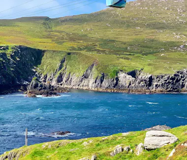
Dursey Island, County Cork, Ireland
Dursey Island
Dursey (Irish: Oileán Baoi) is one of the few inhabited islands off the southwest coast of Ireland. Situated at the western tip of the Beara Peninsula in West Cork, the island is approximately 6.5 km long and 1.5 km wide.
Dursey is separated from the mainland by the narrow Dursey Sound, whose strong tidal race makes it one of the most distinctive stretches of water along the Beara coast. A reef of rocks lies in the centre of the channel and is submerged at high tide.
This peaceful island currently has six permanent residents and is connected to the mainland by Ireland’s only cable car. There are approximately 15 habitable houses on the island, as well as seven farmers who keep livestock here. Many of these farmers were born in one of the island’s houses and regularly stay overnight, although families with school-age children generally maintain their main residence on the mainland.

Derrynane Beach, Darrynane More, County Kerry, Ireland
Derrynane House & National Park
Daniel O’Connell House – Derrynane House
At the southern tip of the Iveragh Peninsula is Derrynane House, the ancestral home of one of the greatest figures of Irish history. Daniel O’Connell, known as ‘The Liberator’, was a lawyer, politician and statesman. The demesne landscape is now included in Derrynane National Historic Park – over 120 hectares of lands rich in natural and cultural heritage with a plethora of archaeological, horticultural, botanical and ecological treasures.
Derrynane was the home of the O’Connell family for generations. The young Daniel was raised there and returned almost every summer for the rest of his life.
The house now displays many unique relics of O’Connell’s life, including a triumphal chariot presented to him by the citizens of Dublin in 1844 and the very bed in which he passed away three years later.
It is a must-visit for anyone in search of insight into the life of an Irish historical giant.

Garnish Island, County Cork, Ireland
Garnish Island
Ilnacullin – Garinish Island
Ilnacullin is an island garden of diminutive size and rare beauty. Nestled in the sheltered coastal harbour at Glengarriff in Bantry Bay, the gardens display a wealth of unique horticultural and architectural gems. Bryce House is a fitting memorial to the visionary creators of this unique place.
The gardens of Ilnacullin owe their existence to the early twentieth-century creative partnership of Annan and Violet Bryce, the island’s owners, and Harold Peto, an architect and garden designer. The area enjoys a mild and humid micro-climate that makes for spectacular and flourishing plant life all year round.
Small ferry boats and 60-seater waterbuses take visitors to Ilnacullin regularly. The short crossing usually includes an extra treat – a visit to the nearby seal colony and an opportunity to glimpse majestic sea eagles.

Allihies Copper Mine Museum, Cloan, Beara, County Cork, Ireland
Allihies
Visit us in Allihies on the Beara Peninsula in West Cork, Ireland and discover breath-taking landscape, a lively village and the captivating story of Europe’s most westerly copper mines!
Allihies, the last village at the end of the beautiful Beara peninsula, sits between an impressive rocky mountain range and the rugged Atlantic coast. The saying ‘a view around every corner’ certainly applies here. The panorama from Barnes gap is unforgettable and, as you descend towards the village through the small fields, the Man Engine house at the Mountain Mine stands out in the grey mountain ahead. Allihies Copper Mine Museum (ACMM), at the foot of the village, bears witness to the phenomenal copper mining industry at the beginning of the Industrial Revolution that changed the land and people of Allihies forever.
Follow your museum visit with a tasty, fresh lunch at the Copper Café. Find a curio at our gift counter, or a book of local stories and history…Stroll around the pretty village of Allihies with its colourful houses or follow the Copper Mine Trail across fields and up mountains! Take on the adventure and find your own route to the most ‘inaccessible museum’ in the country!


The Square, Kenmare, County Kerry, Ireland
Kenmare
History of Kenmare
Sir William Petty established a settlement/plantation scheme here ("Kilmare") around 1670 comprised of English, Cornish, and Welsh protestants. It wasn't however until around 1775 when the 1st Marquess of Lansdowne (William Petty-Fitzmaurice) took an interest in the settlement that the town took on its present shape.
He directed that the town's two streets (Henry Street and William Street) be designed to cross each other at an angle thus creating an " X shape " street plan complete with a triangular marketplace. It is thus one of Ireland's first "planned towns".
The influence of the "Marquess of Lansdowne " can be still seen today in the names of some of the local buildings (Lansdowne Arms hotel, once the town residence for William Petty – Fitzmaurice) to the title deeds of many of the lands in and around the Kenmare area which still bear references to the Marquess of Lansdowne.
Originally a plantation colony, Kenmare is a small and attractive town set on a deep bay between the Macgillycuddy Reeks to the north and the Caha Mountains to the east. The Irish name for the town is "Neidin" which translates as "little nest" a reference many believe to the "nesting" location of the town between the two mountains.
From Kenmare Pier, you will see the beautiful Kenmare Bay stretch for as far as the eye can see, which is a spectacular sight on a fine day (fine days can be a rarity in Kerry). One of the most striking features of the town of Kenmare is its colorfully painted houses and shops. The town has won and has been runner-up in the "Irish Tidy Towns Competition" on many occasions. The town library is one of the "Carnegie Libraries" funded by philanthropist Andrew Carnegie.
As well as being located on the Ring of Kerry, the town of Kenmare is also on the Ring of Beara, another well-regarded tourist trail in the South West.

The Square, Kenmare, County Kerry, Ireland
Kenmare Food Tours ; Karen Coakley
Kenmare Foodie
In 2018 she started her Kenmare Foodie Tours and finally took the ultimate step in coming out of her Kitchen and starting a little business which she has nurtured very carefully and in 2023 launched her second lot of Food Tours in Killarney. Karen has over the years given cookery demonstrations both publicly and at various Food Festivals and events all over Ireland and Privately in peoples homes.
Join TV Cook and Irish Food Blogger Karen Coakley for a 2.5 hour Walking Tour in one of Irelands much loved and best known food towns, Kenmare or in Irelands iconic and premier tourist destination, Killarney.
Kenmare Foodie Tours is born out of a love for food, Kerry and the people behind the food. Karen started her Food Blog in 2013 as a way to share her love of food, her family recipes and a little piece of where she lives. It has grown from strength to strength over the years and this has led to her starting up her Food Tours alongside recipe creation and cooking live on RTÉ Ones Today Show.
Karen has been featured on Radio and in many publications and Kenmare Foodie Tours were named one of The Top Ten Food Tours in Europe in The Irish Independent in December 2022. In 2023 Karen launched Killarney Food Tours.
A highlight was in 2022 being asked to give US Country and Western Singer Miranda Lambert and her husband Brandon a Private Cookery Demo while they holidayed in Ireland.